|
Thunderstorms
single cell, multicell clusters, multicell lines and
supercells
The breakdown into single cell, multicell, and supercell covers
the major storm types within the spectrum. One "cell" denotes
one updraft/downdraft couplet.
Thus, there are several updrafts and downdrafts in close proximity
with a multicell storm. Multicell storms can be broken down
further into the categories of multicell line and multicell
cluster storms.
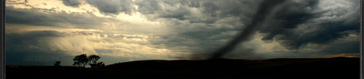
The "intense" updraft storm is almost invariably the supercell,
a storm capable of producing the most devastating weather, including
violent tornadoes.
With the two multicell storm categories, we have defined four
basic storm types from the thunderstorm spectrum. The supercell
is always severe, whereas the others can be non-severe or severe.
We stress that a "severe" storm is a somewhat arbitrary National
Weather Service definition of a storm with one or more of the
following elements: 3/4 inch or larger diameter hail, 50 KT
downbursts, and tornadoes.
Single cell storms typically do not produce severe weather and
usually last for 20-30 minutes. Also known as pulse storms,
single cell storms seem quite random (perhaps because of our
lack of understanding) in the production of brief severe events
such as downbursts, hail, some heavy rainfall, and occasional
weak tornadoes.
The "degree of predictability" is extremely low as forecasters
are never quite sure which storm will produce severe weather
and from which portion of that storm the severe events will
occur. However, the microburst threat to aviation cannot be
over-emphasized.
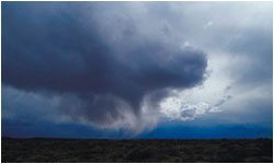
This is a single cell storm, looking east from about 15 miles.
The storm was moving east (into the photo). Some of the anvil
cloud has been left behind the storm, but the greater portion
of the anvil is blowing off in advance of the storm and is not
observable from this perspective. (May storm in the Texas Panhandle
near Amarillo.)
|
|